Shifting Ground, Shrinking Representation: How a Warming Alaska Is Redrawing the Democratic Map
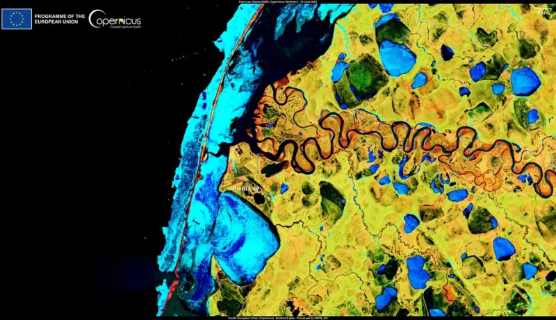
Photo: European Union, Copernicus Sentinel-2 imagery, Attribution, via Wikimedia Commons
In most American states, the phrase "the ground shifted beneath us" is a metaphor. In Alaska, it is increasingly a statement of geological fact — and it is beginning to carry profound consequences for how this state governs itself.
Permafrost, the frozen subsoil that underlies roughly eighty-five percent of Alaska's landmass, is thawing at a rate that scientists describe as unprecedented in recorded history. The visible results — sinkholes swallowing roads, foundations cracking, riverbanks collapsing into the water — have been documented extensively. What has received far less attention is the quieter, slower crisis unfolding in the realm of democratic representation: as communities become uninhabitable or physically inaccessible, Alaska's political map is becoming a document in constant need of revision.
A Geography That Refuses to Hold Still
Alaska's redistricting process, conducted every ten years following the federal census, is already among the most legally and logistically complex in the nation. The state's sheer size, its sparse and unevenly distributed population, and its patchwork of incorporated boroughs, unincorporated areas, and tribal lands make drawing fair electoral districts a formidable challenge under ordinary circumstances.
Climate change has introduced a variable that no redistricting board was designed to handle: geography itself is in motion.
In communities like Newtok, Shishmaref, and Shaktoolik, residents have been engaged in years-long relocation efforts driven not by preference but by survival. Coastal erosion, accelerated by the loss of sea ice that once buffered shorelines, is consuming land at alarming rates. Newtok, which voted in 2003 to relocate to a site nine miles inland, has spent nearly two decades navigating a bureaucratic maze of federal, state, and local approvals — all while the original village continues to erode into the Ningliq River.
During that transition period, a fundamental question arose: where, exactly, do Newtok's residents vote? And which electoral district do they belong to — the one defined by the land they are leaving, or the one that encompasses the land they are moving toward?
The Legal Vacuum at the Center of the Problem
Alaska's Division of Elections and the Alaska Redistricting Board operate under statutes that were written with fixed communities in mind. Voter registration is tied to a residential address. Electoral districts are drawn around census-designated places. Neither framework contemplates a scenario in which a community's physical location is a years-long open question.
Legal scholars who have examined the issue note that Alaska is operating in largely uncharted territory. The Voting Rights Act requires that minority communities — and Alaska's rural villages are overwhelmingly Alaska Native — receive fair and effective representation. But when a community is mid-relocation, its population may be split between two locations, neither of which may have adequate infrastructure to serve as a polling site.
In Newtok's case, residents have at various points cast ballots in locations that required travel by boat or small aircraft. For a population that already faces significant barriers to civic participation, the additional friction introduced by physical displacement is not a minor inconvenience — it is a structural impediment to democratic access.
The state has, to its credit, attempted to address some of these challenges through expanded absentee voting and mobile voting units. But these are workarounds, not solutions. They do not resolve the underlying question of how electoral districts should be drawn in a landscape that is measurably, verifiably changing between census cycles.
Representation in the Age of Thaw
The implications extend beyond communities that are actively relocating. Across interior Alaska, permafrost degradation is making roads impassable for longer periods each year. Communities that were once accessible by winter ice roads are finding those routes unreliable or entirely gone. The practical effect is that some Alaskans are becoming more isolated from the governmental institutions — polling places, borough offices, state agency field offices — that are supposed to serve them.
Isolation, in a democratic context, is another word for disenfranchisement.
Members of the Alaska Redistricting Board have acknowledged in public sessions that the traditional tools of their trade — census data, municipal boundaries, road networks — are increasingly inadequate for capturing the lived reality of rural Alaskans. A district drawn on a map may look contiguous and reasonably compact. On the ground, it may encompass communities that are effectively cut off from one another for months at a time.
Some advocates have called for a more dynamic approach to redistricting in Alaska — one that incorporates not just population data but infrastructure assessments, climate vulnerability indices, and tribal governance boundaries. Such an approach would be legally novel and politically complicated. It would also, its proponents argue, be far more honest about the actual conditions under which Alaskans exercise their democratic rights.
A Statewide Problem Wearing a Rural Face
It would be a mistake to frame this exclusively as a rural issue, even though rural communities are bearing the most immediate burden. The fiscal and legal costs of managing climate-driven displacement will ultimately be distributed across the entire state. Court challenges to redistricting plans that fail to account for displaced communities will consume public resources. Federal oversight of Alaska's compliance with the Voting Rights Act may intensify if the state is seen as failing to protect the representational rights of Alaska Native voters.
There is also a longer-term demographic dimension. If climate change continues to make certain parts of Alaska uninhabitable, and if the state lacks a coherent legal framework for managing the resulting population shifts, the redistricting chaos of the next decade could make the current situation look orderly by comparison.
Alaska has always been a place that demanded creative governance. The distances are too great, the communities too diverse, and the conditions too extreme for off-the-shelf solutions imported from the lower forty-eight. What the permafrost crisis demands now is that same spirit of adaptation applied to the machinery of democracy itself.
What Needs to Happen
The Alaska Legislature should direct the Redistricting Board to develop formal protocols for communities in active relocation or climate-driven transition. Those protocols should address voter registration continuity, polling site designation, and district assignment in a manner that prioritizes uninterrupted civic participation.
The state should also engage directly with tribal governments, which often possess the most current and granular knowledge of how landscape changes are affecting specific communities. Meaningful consultation — not perfunctory notification — is both a legal obligation and a practical necessity.
Finally, Alaska's congressional delegation should be pressing federal agencies, including the Census Bureau and the Department of Justice, to develop national guidance on climate-driven displacement and electoral administration. Alaska is not the only state that will face these questions, but it is the one facing them first and most acutely.
The permafrost does not care about election cycles. It does not pause while redistricting boards deliberate or while legislatures debate. The ground is moving, and Alaska's democratic institutions must find a way to move with it — or risk leaving some of the state's most vulnerable residents without a meaningful voice in their own governance.